

Your municipality
from the air. You choose where to fly.
An interactive video flight is a drone film linked to a map. A visitor clicks a church, a school or a lake, and the drone flies smoothly to it, circles it and tells its story. You see not only the places but also how they come together into one area.
A photo shows a place. A video flight shows the area.
Drone photos and 360° spheres are single frames: pretty, but cut off from each other. A video flight leads the viewer from point to point, the way a guide would.
| Drone photos | 360° sphere | flywow video flight | |
|---|---|---|---|
| What you see | One frame | A view all around from one point | Movement over the whole town |
| The way between places | Not visible | A jump from point to point | A continuous flight: you see roads, rivers and distances |
| Who decides what to watch | The photographer | The viewer, within one point | The viewer, on the map or in the list of places |
| Descriptions and narration | A caption under the photo | Depends on the provider | Descriptions in Polish, English and German, narration in these languages |
| On a phone | Comfortable | Dragging a finger across the frame | Full-screen film, a place chosen with one tap |
The strengths of a video flight
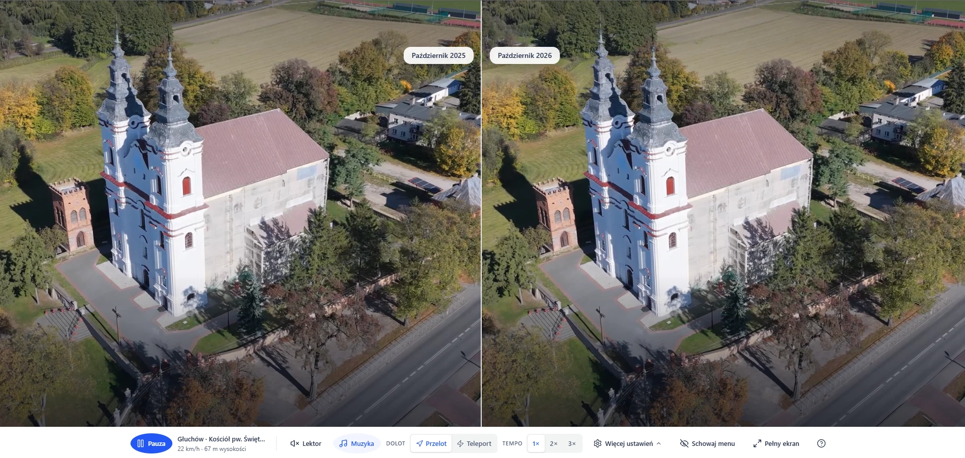
One link that works in the browser on a computer and a phone. No app to install and no account to create. A video flight is not a one-off film. Our flights guarantee a one-to-one before-and-after comparison: thanks to the latest equipment and our team's experience, a recording in six months or in five years will show the area from exactly the same perspective.
- A film synchronised with the map
- The minimap shows where the drone is and where the camera looks. A click on a point on the map is a flight to it.
- Flight and orbit
- The drone flies to the chosen place and then circles it. You can also jump straight to the place.
- Descriptions in three languages
- A description of the town and of every point in Polish, English and German, editable at any time.
- Narrator
- On request, reads the descriptions in the page's language when the drone reaches a place.
- Picture up to 4K
- The viewer chooses the quality and speed of the film, from a calm 1× to a fast 3×.
A before-and-after archive
Every flight stays in the archive. Over the years it becomes a chronicle of the municipality: a new road, a school after its energy retrofit, a housing estate where a field was, a market square before and after its renovation.
Four seasons
The same route in spring, summer, autumn and winter. Tourists see the area in the season they want to come, and residents see their town in every guise.
- Documenting investments
- The site before, during and after construction. Material for promoting projects and for grant reports.
- Consulting residents
- The site of a planned investment shown from above, with its access and surroundings.
- Comparison after events
- After a storm or a flood, a flight along the same route shows what has changed since the previous recording.
- Partners abroad
- Descriptions and narration in English and German for partner municipalities, investors and tourists.
- One film, many uses
- The municipality's website, social media, tourism fairs, a presentation for an investor, a school lesson.
- Descriptions always up to date
- A new street name, a newly opened community centre, new museum hours: we update the description without flying again.
What you get with the video flight
- Recordings on physical media
- We also hand over the footage on physical media, so the municipality has its own copy of the recordings.
- Social media kit
- Ready-made material for the municipality's profiles to announce the video flight to residents and tourists.
- Access to the app and the archive for the next year
- For the next year, the video flight runs at your link, together with the archive of recordings.
From an idea to a bird's-eye view
You choose what to show. Planning, flights, editing and descriptions are on us.
-
A conversation
We choose towns and points: monuments, schools, sports fields, lakes, trails, investment sites.
-
Flight plan
We plan the drone's routes on a map with a terrain model and check obstacles and airspace zones.
-
Recording
The drone flies the planned routes. When conditions do not allow it (strong wind, rain, snow, fog), we do not fly and move the flight to another day.
-
Production
We edit and polish the recordings, prepare the graphics, write and translate the descriptions, record the narration and put it all together into a finished video flight.
-
Publication
You get a link* to the video flight. You can now admire your area from above and show it to others.
* A video flight can also work as a view on your website or as a new site with its own address. We provide full help with setting it up.
Who it is for
For anyone who wants to show a place in motion, not on a postcard.
- Municipalities and districts: promotion, tourism, the website and social media.
- Investment offers: investment sites with their access and surroundings.
- Local action groups: the trails and attractions of several towns in one journey.
- Tourism and spas: the area a guest sees before arriving.
- Monuments and parishes: a building from every side, with a description and narration.
- Schools and cultural centres: a lesson about your own town from a bird's-eye view.
Funding
A video flight can be funded in whole or in part from external funds for municipalities, villages and local action groups, for example from calls for tourism, local heritage or smart villages (Smart Village). Check whether money is waiting to promote your area (the sites are in Polish):
- Grant search (Wyszukiwarka Dotacji) EU and regional calls for local governments in your region.
- Local action group database Find your local action group (LGD) and its calls, including small grants for villages.
Individual quote
We price every video flight separately, because every municipality is different. The price depends on:
- the number of towns and points to show,
- the distances between them and the travel,
- the languages of the descriptions and the narration,
- further flights: the seasons and an archive of the following years.
The more details you give us, the more precise our quote. It helps to mention:
- the towns and points you want to show,
- what the video flight is for: promotion, tourism, an investment offer, documenting investments,
- the languages of the descriptions and whether with narration,
- where it should work: a link, a view on your website or a separate site with its own address,
- whether you are thinking of further flights: every year, in every season (4 flights a year), keeping an archive,
- the planned date,
- whether you are applying for funding and from which programme.
We will reply with a quote.
Prefer e-mail? Write to: office@flywow.pl
Questions
Are drone flights over a town legal?
Yes, within the rules. We plan every flight with a map of airspace zones and in line with drone regulations. The drones are flown by qualified pilots.
How does the video flight reach residents and tourists?
You get a link. You can put it on the municipality's website, in social media, a newsletter or on a board with a QR code.
Can we repeat the flight in a year?
Yes. The drone flies the same way as before, and the recordings from different years and seasons can be compared.
Can we change the descriptions later?
Yes. We change the descriptions and the narration without flying again.